We combine satellite imagery, precision tools, cropping, soil and on-farm data; with expert agronomic advice to help you make faster, smarter decisions without adding complexity to your day.
You can access satellite imagery to help assess crop biomass, target field walking, and build VR plans. By providing you with NDVI and GCVI data, we help you monitor crops all year round. Through our partnership with Aspia, you also have access to ClearSky – an industry-leading, cloud-free alternative to traditional satellite imagery.
The weather data you receive is accurate to within 1km, giving you valuable decision-making tools at a resolution relevant to your farm. From identifying the best time to drill based on soil moisture and temperature, to planning optimum spray windows using windspeed, or looking at historical trends, this data gives you the best insights available when you need them.
Pest and disease models help you plan applications more effectively by providing detailed forecasts tailored to your farm’s local weather conditions. Powered by real-time data from our partner, these forecasts are continually reviewed and updated to ensure you have the most accurate and up-to-date information available.
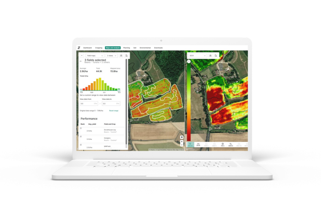
Contour Mobile is a simple, powerful scouting tool, already used on thousands of farms across the UK. You can access satellite imagery, soil sample data, yield maps and historical observations – even offline. Record pests, weeds, and diseases, track problem areas, and log environmental schemes. Fully compatible with the RHIZA desktop platform and included with every package, Contour Mobile is the ideal scouting tool for both you and your agronomist.
You can easily upload and analyse yield maps within the Contour platform. Maps from any manufacturer can be uploaded, with all data automatically cleaned and converted in the background. The easy-to-use tools within the module allow you to explore your data and compare multiple layers simultaneously, such as soil analysis and satellite imagery – enabling analysis of in-season and in-field trends.
Soil information – including classification, organic matter, and calcium levels – is provided by Cranfield University and the James Hutton Institute for every field or zone, giving you valuable background data from the moment you set up your farm.
The integration with TELUS Crop Management (TCM), the next generation Farm Management System replacing Gatekeeper and Muddy Boots, will bring farm benchmarking and gross margin mapping directly into Contour.
Your nutrient management planning (NMP) tool allows you to plan, track, and record nutrient applications throughout the growing season. By combining organic and inorganic fertilisers with VR applications, this intelligent tool helps ensure compliance with government regulations across your grass, combinable, fruit, and vegetable crops.
Through the Contour platform, you have access to tools for planning and mapping environmental schemes, as well as reporting on activities and specific sustainability actions. Using the Contour Mobile app, you can record observations in the field by tagging a specific location, uploading a photo, and adding a description – all of which can be used later in reports. Whether it’s integrated pest or soil management plans, or evidencing actions for payment schemes, it’s all covered with quick, intuitive tools.
With all the compliance tools you can access, generate comprehensive, regulation-ready reports. Backed by years of development, they’re designed to support successful inspections.
Fast, compliant and easy-to-use IPM and soil management tools. With product use, soil health and sustainability now linked to payments, RHIZA helps you create clear, compliant plans with ease..
Designed for simplicity, your livestock and manure management planning tool helps you create compliant plans with ease. It streamlines manure management and compliance requirements, such as stock density, slurry storage, and manure import and export.